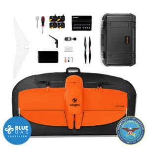
Wingtra Oblique Sony A6100 Payload Kit
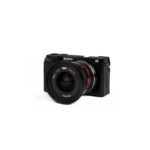


Wingtra Oblique Sony a6100 Payload Kit (Gen 2)
$4,500.00
Optimized to map vertical structures, the Oblique Sony ɑ6100 allows you to generate high-resolution 3D meshes with centimeter-level absolute accuracy.
Request a Quote
Optimized to map vertical structures, the Oblique Sony ɑ6100 allows you to generate high-resolution 3D meshes with centimeter-level absolute accuracy.
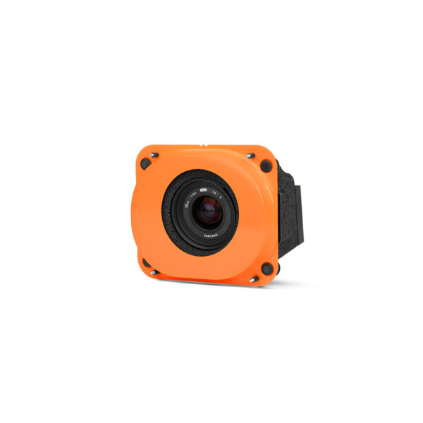
Optimised for 3D
WingtraOne’s oblique solution with the fast-triggering ɑ6100 camera and wide-angle 12 mm optics in a tilted mount makes for the optimal solution to map 3D structures, from single buildings to full-scale cities.
A low-oblique configuration
The WingtraOne oblique solution combines the high-end Sony a6100 camera with a wide-angle 12mm lens in a tilted mount and low-oblique configuration.
If you are mapping bare earth or open fields, a camera looking straight down is the best solution, because the different points in your image are the same distance from your camera.
If you want to map 3D structures like buildings or highwalls, you want to capture enough detail on the vertical walls. A low-oblique configuration provides a wide field of view to the front and sides, making it the best solution to capture a maximum of detail.
Sensor type:
24 MP APS-C
Lowest GSD:
1.6 cm/px Multispectral
Coverage at 120m:
180 ha at 3.9 cm/px GSD*
Absolute horizontal accuracy down to:
2 cm** Without GCPs
Horizontal field of view:
90° (-45° … 45°)
Vertical field of view:
66° (-18° … 48°) tilted to the front
* For successful 3D mapping, high side and front overlaps are recommended. The specified numbers refer to the suggested default values of 80% side and 85% front overlap
** Horizontal absolute accuracy (RMS). Achievable with a WingtraOne GEN II and its built-in GNSS PPK module. This level of accuracy is achievable under optimal conditions, on hard surfaces, using a well-established base station or data from a CORS network. A minimum of three ground points should be used as checkpoints to verify and prove the accuracy of the project.
Technical specifications
Technical specification: 24 MP, APS-C sensor, 12 mm lens, low oblique configuration
Payload weight (incl. mount): 730 g (1.61 lb)
Lowest possible GSD:
1.6 cm/px
0.63 in/px
Maximum coverage at lowest GSD:
Up to 70 ha (180 ac) at
49 m (161 ft) flight altitude
Maximum coverage at 120 m (400 ft):
Up to 180 ha (450 ac) at
3.9 cm (1.54 in) GSD
Horizontal absolute accuracy (RMS) with PPK (w/o GCPs):
down to 2 cm (0.8 in)
Vertical absolute accuracy (RMS) with PPK (w/o GCPs):
down to 4 cm (1.6 in)
Sensor type: APS-C
Sensor size x: 23.5 mm (0.93 in)
Sensor size y: 15.6 mm (0.61 in)
Mega pixel: 24.2
Shutter type: Focal plane
Pixel in x: 6000
Pixel in y: 4000
Focal length of lens: 12 mm (0.47 in)
Focal length (35mm equivalent): 18 mm (0.71 in)
Front tilt angle (off-nadir): 15°
Vertical field of view: 66° (-18° … 48°)
Horizontal field of view: 90° (-45° … 45°)
Minimal trigger time: 1 s
Minimal trigger distance 16 m (52 ft)
GSD Overview
GSD at 120 m flight altitude: 3.9 cm/px (1.54 in/px)
Flight altitude: 120 m (400 ft)
Maximum frontal overlap: 90%
Maximum coverage: 180 ha (450 ac)
Lowest possible GSD: 1.6 cm/px (0.63 in/px)
Flight altitude: 49 m (160 ft)
Maximum frontal overlap: 75%
Maximum coverage: 70 ha (180 ac)
3.0 cm/px GSD: 3 cm/px (1.18 in/px)
Flight altitude: 92 m (300 ft)
Maximum frontal overlap: 87%
Maximum coverage: 140 ha (350 ac)
6.0 cm/px GSD: 6 cm/px (2.36 in/px)
Flight altitude: 184 m (600 ft)
Maximum frontal overlap: 93%
Maximum coverage: 280 ha (690 ac)
8.0 cm/px GSD: 8 cm/px (3.15 in/px)
Flight altitude: 245 m (800 ft)
Maximum frontal overlap: 95%
Maximum coverage: 370 ha (920 ac)
Highest possible GSD: 25 cm/px (9.84 in/px)
Flight altitude: 766 m (2510 ft)
Maximum frontal overlap: 95%
Maximum coverage: 1050 ha (2600 ac)
| Dimensions | 35 × 30 × 20 in |
|---|